Wednesday, June 29, 2011

6/29 - Day 26

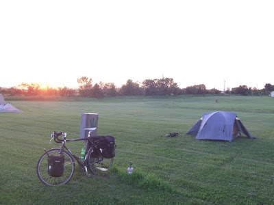
As beautifully as the sun sets (see 6/28 post), it rises.  Camping area.  Enderlin, ND.
Morning paint chips.  Tesoro Gas Station.  Enderlin, ND.
Morning 're-charge' at the Tesoro Gas Station.
While much of the water is due to flooding, some of it is naturally occurring, including this area and many others strewn along State Route 46W.  They render the sky in rippling reflections. 
The horizon is far-reaching on the lonely roads of North Dakota.
Most major + minor cities/towns (relatively speaking) are situated a good 3-10 miles from thoroughfares such as SR46.  Proper food + hydration are critical, just as much as early starts on the hot days, like today.
View of James River valley along SR46.  I believe these to be canola flowers.  The photos don't quite speak to the brilliant yellow they displayed in the sun.
Cruising SR46.  Westbound.
Yet another detour created a decision point.  Since I wasn't sure what this detour consisted of, and had little water left, I decided to head into Jamestown to re-group and re-route a bit.
This farm equipment supply store's front lot was covered with high waters.  Along SR218 northbound.
These cattle were far worse-off however, as they were literally surrounded by standing water, the depth of which I assume to be a min 2ft, given the following photos.
Half this horse pasture was under water.  Giving the horses little room to roam as well.  The minor fence posts that separate the typical cattle pasture from the roadway are covered up to 4" from their tops, and can't even be perceived in this image.
Frontier Fort.  Campground for the evening.  Apparently this souvenir shop + bar/grill is a replica of the typical frontier forts of the 1800's.  This campground is a hodgepodge of museum (National Buffalo Museum), tourist stop, camping area, and rather unique for this reason.
Evening paint chips.  Wagon Building.  Jamestown, ND.
Windmill.  Frontier Village (historic village part of campground).  Jamestown, ND.
Jamestown is alternatively known as the Buffalo City, so I'm told.
This is why.  Albino buffalo at bottom right (foreground); world's largest buffalo at top left (60 tons of concrete - 1959 sculpture).
Touching the whiskers of the concrete giant.

6/28 - Day 25

Leaving Wagner Park Campground.  Extremely well maintained with nicest bath house I've seen to date.  A gentleman all the way from Alaska agreed as we surveyed its cleanliness.
Texture.  Highlighter yellow jacket in early morning shadow.  Noticed + taken while journaling.
County Road headed into Fargo.  An almost continuous roadside swale which offered beautiful reflections of the saturated greens and blues.  This and the nicely finished road surface made for great morning riding.
Approach into North Dakota.  VAST country.
More smile propaganda :)  How can one not smile when seeing this?
I stopped at the Atomic Coffee (coffee, wine, beer bar, all-in-one) for a coffee and internet, and discovered they have Surly beer on tap.  This was meaningful to me mainly because I ride a Surly bike (Surly Long Haul Trucker), and had never seen the beer.  Given the need to cover plenty of mileage after this stop, I asked for just a sample.  The Atomic staff gladly obliged and served up the powerfully tasty Surly Furious.  If the joy of riding my bike could be poured into a glass, this is how good it would taste.  Wow.  Thanks Atomic Coffee! (oh yeah, the coffee was great too!)
Detail.  Expansion joint.  Veterans Memorial Bridge from Moorhead, MN into Fargo, ND.
I Fargo.
In spite of studying the NDDOT road closure map, just west of Fargo I encountered some high waters.  Thankfully for me none of the waters were entirely covering roads (note, entirely, see below), but my heart goes out to the many farmers and families suffering through these terrible floods.  Unreal.
Picture = 1000 words.  West Fargo, ND.
Same.
The high water levels, though not covering roads, did make for difficult (nearly impassable at times) road conditions, with saturated sand literally giving way under my tires.  This, coupled with an unexpected 'Dead End', changed the day's course, needless to say.  I made way quickly for some paved roads to gain speed/time, but North Dakota isn't exactly a highly paved state, so routes aren't quite as direct as in other states.  After finding a paved (and non-freeway) route, I began the detour, right into 17 miles of headwinds.  This meant having to face shorter mileage for the day.  The positive is that these challenges truly make one stronger.
Red, White, and Blue.  What an impressive nation we have.  I am extremely grateful to have this opportunity to soak in its beauty from the saddle each day. 
Detail.  Holding towers at Canola Oil Processing Plant (can you smell them?  this was the most intense olfactory experience to date --> and it wasn't particularly pleasant, haha).  The silver lining?  Getting to see a canola oil processing facility.  Apparently ND produces quite a lot of it.
Enderlin, ND.  Campsite for the night.  $Free.99!  The city allows travelers to come and camp on a lawn with free power + water.  I almost couldn't believe it either!?!  The townspeople were super kind and helpful, the benefit of the day's redirection.
Sunset from the camping area.  Enderlin, ND.

Blog Archive